ADVICE FOR SMALL CRAFT VISITING BRIGHTLINGSEA HARBOUR
How to enter Brightlingsea Harbour Harbour navigational entry video
Download Chart Here Pilotage Map for more accurate depths see below
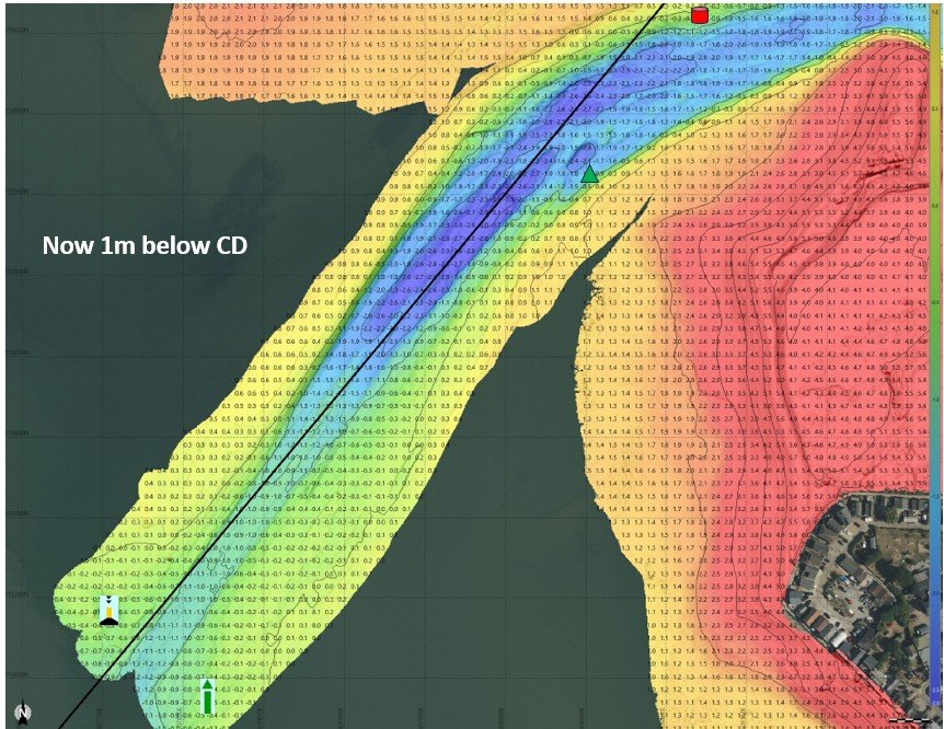
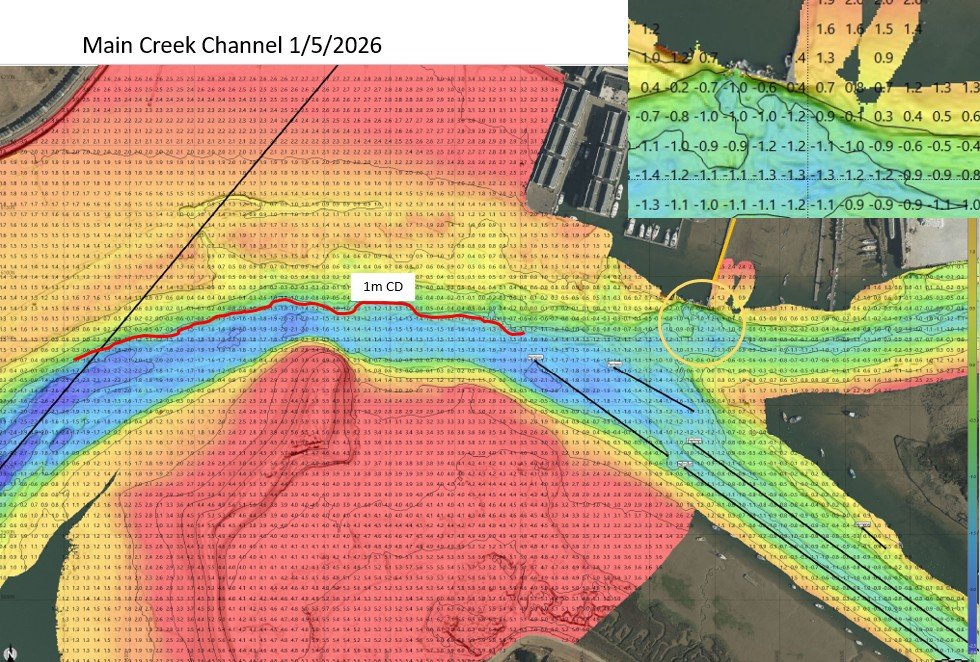
Bathymetric survey Dated May 2026 all buoyage symbols are marked, leading line in Black. Spot heights are marked + or - Chart datum.
Entry Channel dated 1/5/2026
Approaching from seaward, pass between red buoy No 10 and green
buoy No 13 and head towards Bateman’s Tower at the entrance to the
creek on the north shore. The entrance to the Creek is marked by a lit
south cardinal buoy ( Brightlingsea Spit Buoy) and a lit green beacon
with a tide gauge showing the minimum depth on the line of the leading
marks into the Creek.
If the south cardinal buoy (Brightlingsea Spit Buoy) is left close to port,
the upper and lower leading marks (locally known as the Cricket
Stumps – 2 white boards with vertical red lines by day and 2 fixed red
lights by night). They are in transit at 041° T and when in line lie just
below and to the left of the thin spire in the town skyline.
Follow a course with the boards / lights in transit. The channel is dredged
to a minimum of 1m below CD. When abeam the green buoy
turn to starboard to pass 50 metres south of the red buoy (Fl R 5s).
When the red buoy is abeam turn further to starboard and
head to pass 10 metres north of the north cardinal beacon (quick flash
by night) at the seaward end of the first pontoon. By day a welcome
board is visible on the beacon.
There is a red buoy (Fl R 6s) on the north side of the Creek which
marks the seaward side of the channel to the Waterside Marina which
has a sill which dries 1m above CD.
REMEMBER: FOR MOORING OR GENERAL INFORMATION
CONTACT BRIGHTLINGSEA HARBOUR ON VHF CHANNEL 68
Vessels have a choice to berth in the harbour or in the marina.
There are normally pontoon moorings available for
vessels up to 50’ LOA. For berthing instructions please call
Brightlingsea Harbour on VHF Channel 68 when approaching.
The waiting area is to the north of the north cardinal beacon (Q Fl)
wait until met by a member of the harbour staff in the harbour launch,
who will guide you to a berth.
If you arrive when there is no member of staff on duty, please follow
the instructions below:-
⇒ Head between the first two pontoons A and B which normally berth commercial
boats and traditional smacks heading towards the next
pair of parallel pontoons.
⇒ Berth on the Southern side of B Pontoon. There is approximately 2 m
below CD on here.
⇒ If these are all taken, go into any empty pontoon berth large
enough for your vessel where there is not a ‘Back Tonight’ notice,
or go alongside another boat on one of the pontoons.
All vessels having to lie alongside other vessels or the pontoon must
place sufficient fenders on the side of their vessel which will be next to
the other vessel or the pontoon. Fore and aft shorelines should be
taken from the outer vessel to the pontoon and springs should be run
to the adjacent vessel or pontoon as appropriate.
N.B. The tides run at up to 2 knots.
⇒ The pontoons lie parallel with the flow of the tide and it is strongly
recommended that except in exceptional circumstances all vessels
should berth bow into the tide.
⇒ There is a turning area with approximately 1 m below CD at
the south east end of the northernmost pontoon.
⇒Vessels should only use the channel between the two pontoons with
great caution and in any case only to go to or leave a berth in that
channel.
⇒ The sea bed in the creek is Mud and keels sink easily into it at low water.